| Click on image to view media |
| 15 animations |
|---|
| media | description |
file size |
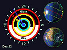 | Sun Angle & Length of Day (3 min)
Solar energy received at any point on the earth varies according to the angle of the sun in the sky. This angle varies with latitude and changes with the seasons. | 5.60 Mb |
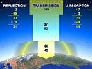 | Global Energy Balance (5 min)
The sun's radiation is the power source for many earth processes. The earth constantly absorbs shortwave radiation and emits longwave radiation (back to space). These energy flows must balance. | 8.47 Mb |
 | Latent Heat (3 min)
Water exists in 3 states. When water changes state from solid to liquid, liquid to gas, or even solid directly to gas, it requires energy input from the surroundings. The energy that goes into changing state is called latent heat. | 6.45 Mb |
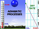 | Adiabatic Processes (1 min 30 sec)
Atmospheric pressure decreases with altitude. As an air "parcel" is forced to rise, it expands. The expanded parcel cools, not from loss of heat energy, but because energy is dispersed over the larger volume. Temperature changes resulting from pressure changes are called adiabatic. An adiabatic process does not lose or gain energy from the surrounding environment. | 3.03 Mb |
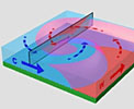
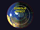 | Coriolis Effect (2 min 32 sec)
If not for the earth's rotation, winds and ocean currents would flow in the direction of initial movement. Because the earth spins, all free moving objects, including masses of air, are "deflected" from their original direction of motion. This is called the Coriolus effect. | 6.11 Mb |
 | Global Atmospheric circulation and Winds Aloft (2 min)
Since insolation (radiation received from the sun) is stongest when the sun is directly overhead, the equator is heated more intensly than other place on earth. Heated air rises and cold air sinks, resulting in low surface pressure at the equator and high surface pressure at the poles. This pressure difference is the engine of low latitude circulation. | 5.23 Mb |
 | Development of Wave Cyclones (1 min 15 sec)
Wave Cyclones form along the unstable contact between cold, dry air and moist maritime air. Some waves develop into strong circulating systems. | 3.22 Mb |
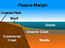 | Tectonic Plate Margins (2 min)
There are three basic types of tectonic plate margins. The "Passive Margin", where continental crust and oceanic crust are in contact, "Sea Floor Spreading", where new oceanic crust is created, and "Subduction, where oceanic crust is recycled beneath continental crust. | 3.55 Mb |
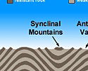 | Landforms and Foldbelts (1 min)
Wedges of setiment are strongly compressed when a continental collision begins. Flat lying strata are compressed creating arch-like "upfolds" and trough-like "downfolds". Erosion wears away the tops of these landforms and produces mountain ranges. | 2.25 Mb |
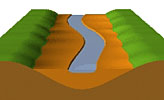 | The graded stream (2 min)
A stream adjust it's channel over time in order to achieve a balance between it's flow and the solid load of silt, sand, gravel and larger particles it carries along. | 3.39 Mb |
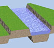
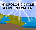 | Hydrologic Cycle and Ground Water Flow (1 min 41 sec)
Water evaporates from ocean and land surface, condenses and then precipitates, much of it over open water. Soil absorbs water by infiltration. Water further percolates down by gravity, until it reaches the water table. | 4.11 Mb |
 | Coriolis Effect revisited (2 min 12 sec)
With the Coriolis Effect, an object in motion appears to be deflected from it's course, as if a force is pulling it sideways. | 5.35 Mb |
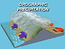 | Orographic Precipitation (1 min 32 sec)
Orographic means "related to mountains". In orographic precipitation, winds move air up and over a mountain barrier. The forced ascent of warm, moist air over a mountain barrier produces precipitation. | 3.31 Mb |
 | Major Types of Faulting (3 min)
In zones of drifting continental plates, the crust is pulled apart. The brittle crust yields by fracturing along a fault. Faulting is accompanied by a slipping motion along the fault plane. Transcurrent faults can become locked, that is they do not slip relative to each other. The lithospheric plates continue to move increasing the pressure along the fault plane. A sudden release of pressure can result in a major earthquake. | 5.55 Mb |
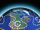
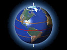
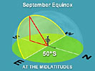 | Sun's path in the sky (3 min 35 sec)
To show how the sun's path in the sky changes from season to season, we look at a small area of the earth's surface, bounded by a circular horizon. To an observer on the surface of the earth, the earth seems flat and the sun appears to travel inside a vast dome in the sky. | 5.73 Mb |
 |